
Structure/Property Name: High Bridge
Street Address/Location: Between 172nd St @ Amsterdam, in Manhattan, N.Y. and West 170th St. @ University Avenue, Highbridge, Bronx, NY.
Town/City: New York, NY and Highbridge, NY
County: Manhattan and Bronx
Owner: New York City Department of Parks & Recreation
STRUCTURE/PROPERTY
Architect/Engineer/Other Responsible Parties: David Douglass, John B. Jervis and James Renwick, Jr., Engineers
Historic Use: Aqueduct and pedestrian Bridge
Present Use: Closed and locked since 1970, campaign to refurbish the bridge is afoot and the goal is to open it to public (pedestrian only) traffic in the next couple years.
Typology: Bridge
Architectural Style: Roman Arch Bridge
Period(s) of Construction: 1839-1842: aqueduct component, 1848: Pedestrian walkway
Date of Decommissioning: 1949
Date(s) of Demolition: N/A
Structural System/Materials: Granite, brick, cast iron
Significant Alterations: 1842: Aqueduct Bridge completed; 1848: pedestrian walkway completed; 1861: 90 inch pipe added; 1927: five stone arches removed and replaced with one 360 foot span arch.
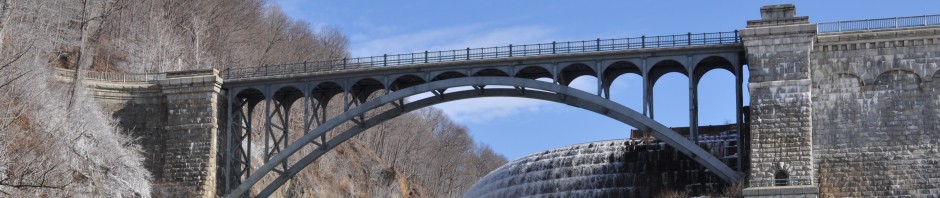
Brief Architectural Description: Built between 1837 and 1848, High Bridge is the oldest bridge connecting two boroughs in New York City, and from 1842 to 1949, served as the Harlem River crossing for the Croton Aqueduct. The upper level of High Bridge functioned, from 1848 until 1960 as a pedestrian and bicycle path connecting High Bridge Park near W. 174th Street in Manhattan and West 170th St in the Bronx. There are plans underfoot now to restore the bridge as a pedestrian bridge and open it once more to foot traffic – perhaps in 2013.
Designed by John B. Jervis and James Renwick, Jr., both engineers, the pedestrian bridge is 1,450 feet across and is supported by fifteen stone masonry arches. The eight arches over the Harlem River were eighty feet wide each, clearing the mean water level by 114 feet, and the seven arches over land were fifty feet wide each. Carrying the Croton water above the arch supports were two thirty-three inch diameter pipes; gates were installed at either end of the bridge’s pipes to control the flow of the water. In 1872, to increase water supply for a growing population, a third ninety-inch diameter pipe was added to the bridge and the footpath on the bridge was raised accordingly.
In 1927, to make the water more navigable for larger ships, five of the over-water eighty-foot span arches were removed and in their place was put a steel plate girder arch with a lateral clearance of 360 feet.
Brief Statement of Historic Significance:
Engineering: The Croton Aqueduct, in its entirety, is considered one of the most significant early 19th c American engineering projects; it was the first of its type in the United States running 41 miles, and relying on a gravity-fed system that averaged a 13 inch drop in elevation per mile. Spanning the Harlem River with multiple sequential arches, the High Bridge was modeled after the Roman aqueducts’ treatment of deep valleys and waterway crossings. Reaching 138 feet above the river’s surface and spanning a total length of 1450 feet, it was indeed a spectacle to behold.
Health: By the early 1830’s New York had experienced outbreaks of cholera (1832) and massive inextinguishable fires (1835); so much, in fact, that public officials were willing to spend public money to find a better quality and more plentiful water supply. The Croton Aqueduct would bring much needed relief to a parched and unhealthy city.
Commerce: The most politically challenging aspect of Engineer Jervis’ leadership on the Aqueduct design and construction involved the High Bridge. His preference was for either an inverted siphon to run beneath the Harlem River, or a low bridge. Property owners, however, saw a “high bridge” as a magnet for potential future customers and thought a navigable river (not possible with a low bridge) might bring more commerce and industry to the area; their persistence paid off.
Social: The High Bridge is one of the more prominent and visible components of the Croton Aqueduct. Connecting the boroughs of Manhattan and the Bronx, it carried not only the water within across the water below, but its existence created a social phenomenon. As soon as it opened, it became a destination place for promenading and taking in the view of the Harlem River and the two bodies of land it connected.
INTERPRETATION
Accessibility to Public: High Bridge is closed and gated off at both ends since approximately 1970.
Landmark Status: The Croton Water Supply System was designated as a National Historic Civil Engineering Landmark by the American Society of Civil Engineers in 1975. High Bridge and High Bridge Water Tower were designated in National Register of Historic Places in 1974 (ref. 72001560); High Bridge was designated as part of the Old Croton Aqueduct National Historic Landmark in 1992 (ref. 74001324).
Threats: The Bridge appears to be in fair shape; however, there is currently a proposal of over $60 million to preserve and rehabilitate the bridge so that it can be re-opened and safe for public use. The bridge is expected to reopen for public use by 2013.
Current Interpretation:
There are two signs in the Bronx side Highbridge Park, one at the northern entrance to the park, noting the park and its history connecting it to the Bridge, and the other, which describes the Croton Aqueduct’s function and history as well as the High Bridge’s importance in both. Interestingly, the second sign is written in both English and Spanish, indicating the possible ethnic make-up of the Bronx neighborhood.
On the Manhattan side, there is a copy of the sign on the Bronx side, denoting the history and function of the Aqueduct and the High Bridge. It too, is written in both English and Spanish.
1862: http://lcweb2.loc.gov/pnp/habshaer/ny/ny1100/ny1175/photos/117651pv.jpg 1900: Photochrom Print Collection, Library of Congress
1928: New York Times Jack Boucher, 1978
SOURCES
Friends of the Old Croton Aqueduct, http://www.aqueduct.org/node/13, as retrieved 2.27.2011.
“The High Bridge,” The N.Y. Times, May 12, 2010, http://www.nytimes.com/2010/05/13/opinion/13thu4.html, as retrieved 2.27.2011.
“The High Bridge and HighBridge Parks” (PDF), High Bridge Coalition. 2005. http://www.nycgovparks.org/web/download/download.php?file=/sub_your_park/highbridge/images/hb_brochure_english.pdf., as retrieved 2.27.2011.
“High Bridge/Aqueduct bridge: Historic Overview,” NYC Roads.com, http://www.nycroads.com/crossings/high/, as retrieved 2.27.2011.
“The High Bridge Coalition,” New York City Department of Parks and Recreation, http://www.nycgovparks.org/sub_your_park/highbridge/html/highbridge.html, as retrieved 2.27.2011.
“High Bridge PlaNYC Project Overview,” New York City Department of Parks & Recreation. http://www.nycgovparks.org/sub_about/parks_divisions/capital/parks/high_bridge.html, as retrieved 2.27.2011.
Lange, Robie S., “Croton Aqueduct: National Park Service National Register of Historic Places Registration Form,” United States Department of the Interior, October, 1991.
FICHE PREPARED BY
Jennifer Frazer
