
GENERAL Structure/Property Name (Current and Original, if Different): Nepperhan/Saw Mill River Bridge/Viaduct
Street Address/Location: 352 Nepperhan Avenue
Town/City: Yonkers
County: Westchester
Owner: Taconic State Parkway Authority
STRUCTURE/PROPERTY
Architect/Engineer/Other Responsible Parties: J.B. Jervis
Historic Use: Conduit for converging rivers, aqueduct and vehicular traffic Present Use: Roadway overpass, Croton Aqueduct walking trail conduit over Nepperhan Avenue Typology: Bridge
Architectural Style: Neoclassical Period(s) of Construction: 1838-1839
Date of Decommissioning: Unknown Date(s) of Demolition: N/A Structural System/Materials: Ashlar stone, hydraulic cement Significant Alterations: Largest arch widened from 20 feet to 50 feet wide; Fourth arch added in 1985 and Nepperhan Avenue rerouted beneath
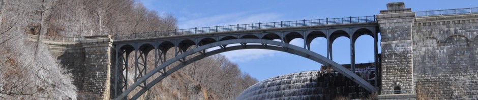
Brief Architectural Description: The structure is notable because Jervis used two smaller arches that shared a common center footing design for the eastern side of the bridge; on the western side, a large arch was used for human and vehicular traffic. Constructed of ashlar stone and hydraulic cement, the Nepperhan Avenue arch of the original structure was altered to accommodate increased automotive traffic; it was widened from twenty to fifty feet in width. In 1985 a fourth arch was added to allow the rerouted Nepperhan Avenue to pass beneath while continuing to support the aqueduct and walking trail that run across the top.
Brief Statement of Historic Significance: The Nepperhan Bridge/Viaduct was designed to provide a conduit for the Croton Aqueduct, Nepperhan (now known as Saw Mill) River, Tibbit’s Brook as well as vehicular and human traffic. The Aqueduct flowed in an enclosed pipe over the bridge archways and embankment, on top of which a footpath was designed as part of the Croton Walking Trail.
INTERPRETATION
Accessibility to Public: Accessible via Old Croton walking trail and from Nepperhan Avenue Landmark Status: N/A Threats: Under the Nepperhan Arterial Project the bridge was altered to include a fourth arch which possibly compromised/caused damage to Nepperhan Bridge and Aqueduct.
Current Interpretation: Signage at trail-level, signposts with “OCA” (Old Croton Aqueduct) engraved on them
MISCELLANEOUS
SOURCES
Clement, Daniel, “Old Croton Aqueduct, Saw Mill River Culvert Spanning Nepperhan Avenue” HAER No. NY-118, 1984.
“Old Croton Aqueduct State Historic Park: History” New York State Parks, Recreation and Historic Preservation website, accessed 24 Feb 2011, http://nysparks.state.ny.us/parks/96/history.aspx.
FICHE PREPARED BY Kaity Ryan
