
Source: westchesterlandtrust.org
GENERAL
Structure/Property Name (Current and Original, if Different): New Croton Reservoir
Street Address/Location:
Town/City: Cortlandt and vicinity
County: Westchester
Owner: New York City Department of Environmental Protection
STRUCTURE/PROPERTY
Architect/Engineer/Other Responsible Parties:
Historic Use: Reservoir
Present Use: Reservoir
Typology: Reservoir
Architectural Style: Picturesque artificial lake
Period(s) of Construction: (ca) 1892-1906
Date of Decommissioning: N/A
Date(s) of Demolition: N/A
Structural System/Materials: Stone walls were constructed in some places.
Significant Alterations: N/A
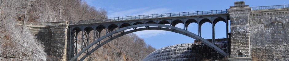
Brief Architectural Description: The New Croton Reservoir was created as part of the effort to expand the water capacity of the Croton Aqueduct system in the 1890s. Croton Lake, the original Westchester County reservoir, was expanded with the construction of the large New Croton Dam, and smaller Muscoot Dam, to form the New Croton Reservoir. Generally twenty miles in length, the reservoir followed the contours of the valley, however stone walls were constructed in some locations to provide an adequate embankment. The New Croton Reservoir opened in 1906 and was capable of impounding thirty billion gallons of water.
Brief Statement of Historic Significance: The construction of the New Croton Dam and the smaller Muscoot Dam, allowed the water level in the New Croton Reservoir to rise 35 feet over the level of the original Croton Lake. The original dam built by Jervis was submerged, along with its outbuildings and gatehouse. Significantly, the land chosen for the reservoir was not barren; four villages had been thriving for decades in the area. The villages of Pine’s Bridge, Katonah, Purdy’s Station, and Croton Falls were condemned by the City of New York in the 1890s and were flooded by the creation of the larger reservoir, along with three railroad lines. Some residents of Katonah purchased their homes for a fraction of their value from the city and moved them to higher ground. Fifty buildings in all where moved along soaped railroad tracks to the new village of Katonah. Newspaper accounts from the period recount stories from the perilous voyage, including one where a contractor left houses suspended on an angle on a hillside for a week with people still living in them.
INTERPRETATION
Accessibility to Public: Boating for the purpose of fishing is allowed with DEP access permits and boat tags. On December 1, 2010, the DEP upgraded access to year round fishing.
Landmark Status: N/A
Threats: Heavy rainstorms can wash untreated human waste into the reservoir.
Current Interpretation: None
MISCELLANEOUS
Historic Image
”]
“Finishing Touches to the New Croton Reservoir,” Scientific American, XCV:8 (25 Aug 1906), 133.
“The City’s Water Supply, Report of Aqueduct Commission Made Public by Mayor Low,” The New York Times, (13 Jul 1903), 6.
“The Croton Aqueduct, Gen. Duane’s Report on the Work Done and in Progress,” New York Times, (10 Jan 1895), 9.
“The Opening of the New Croton Reservoir,” Scientific American, XCII:15 (15 Apr 1905) 302.
The Surveyor and Municipal and County Engineer, 30 (July 6 to Dec 28, 1906), 30.
“Water Supply, Development of the Croton Watershed” Scientific American, XCIX:28 (5 Dec 1908) 394
“Westchester County, Destroying the Village of Katonah,” The New York Tribune, (25 Nov 1896), 12.
“World’s Biggest Reservoir New York’s New Year Gift,” The New York Times, (24 Dec 1905), SM3.
Lewis, Myron H., “Saving Millions of Gallons of Water from the City through the Croton Watershed Described” The New York Time,s (10 Apr 1904), 11.
FICHE PREPARED BY
Sarah Morrison/ February 27, 2011
